Everything is flowing — going somewhere, animals and so-called lifeless rocks as well as water. Thus the snow flows fast or slow in grand beauty-making glaciers and avalanches; the air in majestic floods carrying minerals, plant leaves, seeds, spores, with streams of music and fragrance; water streams carrying rocks… while the stars go streaming through space pulsed on and on forever like blood…in Nature’s warm heart. – From John Muir, My First Summer in the Sierra (1911)
Never in my life have I felt more in the center of Muir’s flow of nature than from a high windy knob on Ball Ridge under the vertical Caroline Face of New Zealand’s highest peak, Aoraki/Mt Cook[1]. Long tongues of glaciers stretched from the high snowfields of the Southern Alps all around us down toward aquamarine Lake Pukaki and the Canterbury plains, with high moraine walls sketching their past extent. Icefalls constantly tumbled down the sheer face before us. The very ridge we had walked this day was flowing, collapsing into the valley below, under the inexorable pressure of snow and water and gravity. Even the skies flowed, with an immense Southern Hemisphere star show from horizon to horizon over our tents the night before in this international Dark Sky Preserve.
In a total space less than twice the size of the Seattle Metro area, New Zealand’s Aoraki/Mount Cook National Park contains 19 peaks over 10,000 feet (including the country’s highest at 12,316’) and 72 named glaciers that cover over 40 percent of the park’s area. Yep, imagine ice from Queen Anne to Rainier Beach and from Century Link field to Mercer Island….in some places over 600 feet deep. It’s an incredible concentration of evidence of the inimitable power of nature – to lift up and tear down, to carve, to transform, to dominate.
Aoraki/Mount Cook Park was the culmination – literally and emotionally – of our three weeks of New Zealand trekking up to that point. Our group of 13 fellow travelers from the Mountaineers club had already worked our way from the Southern Ocean vistas of the Hump Ridge Track in far-south Fiordland, up and over McKinnon Pass on the iconic Milford Track, along a high ridge overlooking the remote craggy Darran Mountains on the Routeburn track, and up cliff walls above the West Matukituki River loomed over by the snowy pyramid of Mount Aspiring. Now our bus had left us in Mount Cook Village: a small scatter of hostels, the historic Hermitage Hotel and a Visitor’s Center tucked in a grassy valley at the toes of the three biggest glaciers and a circle of high peaks. It was the first week of March 2012, still prime summer tramping season in N-Zed, and we were enjoying a record warm sunny spell that had blessed us for nearly our entire trip. From the comfy deck and bountiful buffet of the Hermitage Hotel, Mount Cook, its snowfields and all the snow-crested ridges radiating out from it were in perfect position to reflect first the amber, then the salmon and fuschia, and finally the brilliant violet of the sunset. A statue of the country’s most famous son, Sir Ed (Edmund Hillary), gazed across the deck to the peak with his rucksack and walking stick at the ready.
The crisp early light of the next morning turned the valley grass to gold as we wound the short way from the village to the base of the steep ridge wall that loomed over it just to the west. From there it was no-nonsense: 1800 steps bolted into the rocky face and winding upward without letup for nearly 2000 feet. But oh the rewards! Behind us, the high lateral moraines of the Mueller, Hooker and Tasman Glaciers subsided into the wide flat Hooker Valley, precipitous ridges rising from all sides. At the top of the steps, a series of small tarns perched on the edge of a vertical dropoff to the Mueller Glacier, with 10,335’ Mount Sefton and its neighboring peaks and glaciers reflecting in the still water and drawing all comers to its warm rocks and transcendent views. Mt Cook herself sat back a bit, indifferent but magnificent, a lenticular cloud capping her rocky top.
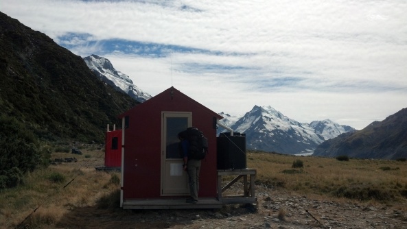
This was the turnaround point for some of our group, but others of us had set our sights on the Mueller Hut, 1500 feet farther up a steep scree slope and across a boulder field on the ridge crest above the tarns. The hut was indeed worth every drop of sweat – an incongruous red, corrugated-metal structure perched like flotsam at 5900’ elevation on a rocky desolate bench, its deck offering a 180 degree view of the snowy sweep of the Cook range and steeply down to the Mueller Glacier thousands of feet below. Behind the hut was Mount Ollivier, a 6340’ rockpile said to be Sir Ed’s first climb and the one that hooked him for life. One can see why, with the full 360 degree panorama it afforded of the rock – and ice-scape of the National Park and the Southern Alps stretching into the far distance south and west.
The next day was departure day for most of our group, heading to Christchurch by bus for flights home or to Auckland for some beach time before our last trek on the North Island. However, three of us had set aside a few extra days for a closer view of Aoraki/Mt Cook herself. We loaded early into a 4WD rig to bump and rattle up the moraine of the Tasman glacier, past the lake at its foot, to the start of an often washed-out boot path between the moraine and the ridge wall, which led in about 2 rocky miles to the tiny 3-bed Ball Hut, with water spigot, outhouse and campsites nearby.
Shortly beyond the hut, the moraine and the ridge tapered away leaving only the vast curve of the Tasman glacier emerging from the snowfields miles to the northwest, and the stark face of Mount Cook rising immediately to our southwest. Needless to say, we were gifted with yet another lingering brightly-hued sunset.
The hike up Ball Ridge from Ball Hut may have been fairly straightforward, if strenuous, at some point in the past. Now, though, both sides of the narrow ridge had sloughed away, and the route required a mix of route-finding and gymnastics through steep scrub, across scree slopes and snowfields, and over and around massive boulders. The rumbling and crackling of the Caroline and Ball Glaciers and icefalls down the cliffs of Mt Cook provided a constant accompaniment. Caroline Hut, a private hut with public water spigot, warming room and outhouse, sat on a bench at nearly 6000 feet with the immense Caroline face looming another 4300 feet above our heads and seemingly close enough to touch. There was just enough time to crest gusty Fergun’s Knob, just beyond the hut and another 400 feet higher, and for one intrepid member of our party to summit 7288-foot Kaitiaki peak with views down to the Hooker Glacier, before we had to descend back to Ball Hut in the fast-fading early evening light.
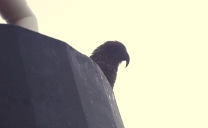
My last, and perhaps most treasured, memory of our Ball Ridge trip: In the grey of very early morning before heading back down the moraine to meet our ride, I was awakened by fluttering, scuttling and pecking on the metal roof of the Ball hut. Cup of hot Via in hand, I made my way to the porch of the hut and settled there wrapped in my down bag. As the light grew I could see the outline of a kea – New Zealand’s iconic alpine parrot – looking down at me from the eave five feet above.
Shortly another kea joined the first one, alighting on one of the hut’s cable supports. Within a handful of minutes there were five, then eight more keas hopping closer, their curiosity and intelligence evident. Eventually, as we packed up and made our way back down the moraine, there was a group of thirteen keas following us, flashing the brilliant orange and green undersides of their wings as they fluttered along the hillside by the trail to keep us in sight, occasionally shrieking ‘KEE-ah, KEE-ah’ to each other. When we would stop to take pictures and enjoy their antics, they would stop to hop and preen and fluff their colorful wings and chatter. Finally there was the heartbreaking, inevitable moment as we neared the trailhead that the keas gathered themselves as if by an unheard signal and flew back up toward the hut, presumably to investigate the next group of visitors to their domain. What a gift of welcome and special joy, to match the treasure chest that New Zealand had already delivered to us.
Aoraki/Mt Cook National Park Standouts: Sunset on the flanks of 12,316’ Aoraki/Mt. Cook from the deck of the Hermitage Hotel, from Mueller Hut and from Ball Ridge; reflections of peaks and glaciers in the crystal water of Sealy Tarns; 360 views from the top of Mt Ollivier of a stark landscape carved by huge glaciers still in motion; excellent programs including an Edmond Hillary film, Planetarium show and star-gazing tour offered by the Hermitage Hotel; fun rock scrambling under the vertical ice-and-rock Caroline Face of Mount Cook from the Ball Ridge trail.
Hut Bookings in Aoraki/Mt Cook National Park
In general the huts in the park are small and remote with few amenities. Routes to some of the higher huts wash out or slough away every year. They cannot be reserved in advance, so stop at the National Park Visitors’ Center when you arrive to check on current accessibility, availability of beds and hold a spot (no more than a day in advance)
Transport to and from Aoraki/Mt Cook:
The nearest gateway towns to Aoraki/Mt Cook Park with airports are Queenstown (about 2.75 hours away) and Christchurch (about 3.5 hours away). Many car rental options exist at the airports in both towns, and a rental car affords by far the best flexibility. Only a few bus companies serve Mt Cook Village, with one or two rather expensive options per day. See Intercity bus lines (http://www.intercity.co.nz/) and The Cook Connection (http://www.cookconnect.co.nz/).
Mueller Hut and Ball Ridge Track Profiles:
- Mueller Hut dayhike – 5.6 miles, 3200’ gain. http://www.doc.govt.nz/parks-and-recreation/tracks-and-walks/canterbury/aoraki-mount-cook/mueller-hut-route/
- Ball ridge backpack – 15 miles and 4000’ gain with side trip to Caroline Hut, 3 days, 2 nights. http://www.doc.govt.nz/parks-and-recreation/tracks-and-walks/canterbury/aoraki-mount-cook/ball-pass-crossing/
[1] The English name of Mount Cook was given to the mountain in 1851 to honor Captain James Cook who first surveyed and circumnavigated the islands of New Zealand in 1770. Following the historic land settlement between the Maori and the Crown in 1998, the name of the mountain (and many other places in New Zealand) was officially changed to to incorporate its historic Māori name, Aoraki.


